Founded in the 17th and 18th centuries, the Thirteen Colonies, were a group of British colonies on North America’s Atlantic coast. They were the first foreign colonies to form the United States.
The colonies started the American Revolutionary War in April 1775 and declared complete independence in July 1776 to create the United States of America.
The Thirteen Colonies had three major protectorates- New England, Middle, and Southern. Territories under New England included New Hampshire, Massachusetts, Rhode Island, and Connecticut.
Likewise, the territories of the Middle consisted of New York, New Jersey, Pennsylvania, and Delaware. In like manner, Southern territories included Maryland, Virginia, North Carolina, South Carolina, and Georgia.
With similar political, constitutional, and legal systems, all Thirteen Colonies were dominated by Protestant English speakers. These colonies were part of Britain’s possession of the New World. Let us take a look into what the Thirteen Colonies were about.
What are the Thirteen Colonies now called?
On September 9, 1776, the Continental Congress officially changed the name of the Thirteen Colonies from the “United Colonies” to the “United States of America.”
When was the USA Colonised?
The Spanish invaded the continent of North America in 1565 at St. Augustine, Florida.
How long did Britain rule America?
With colonial territories of the British Empire, British America lasted from 1607 to 1783.
13. Province of Georgia (Estb. 1732)
Content
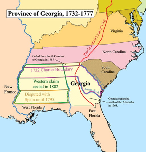
The last of the thirteen colonies, the Province of Georgia, also called the Georgia Colony, was one of the Southern colonies established by Great Britain. King Gorge II granted the colony’s corporate charter to General James Oglethorpe on April 21, 1732. He named the colony after himself.
Gorge II’s privy council finalized the charter on June 9, 1732. As per the original grant, a tapering strip of the province also extended to the Pacific Ocean.
Oglethorpe said the colony was supposed to be a haven for English subjects imprisoned for debt. It was also a colony that served “the worthy poor.”
However, during his time as the colony’s general, Oglethorpe obtruded strict laws that were disagreeable for many colonists, such as banning alcoholic beverages. He was also in an altercation with the idea of slavery.
Instead, he thought a system of smallholdings was more appropriate than the large plantations common in the northern colonies.
Another reason King Gorge II founded the colony was to make this colony a buffer state. A “garrison province” guarded the southern British colonies against Spanish Florida.
Because General Oglethorpe wanted a province populated by substantial farmers capable of guarding the border, the colony’s charter prohibited slavery. Nevertheless, the King lifted the ban on slavery by 1751, and the colony became a royal colony by 1752.
12. Province of South Carolina (Estb. 1712)
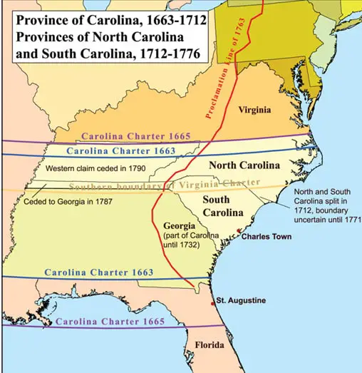
Formally known as the Clarendon Province, South Carolina was a province of Great Britain and one of the thirteen colonies of America’s Southern protectorate.
The first settlement within South Carolina was Charlestown, established in 1670 and named after King Charles II.
The King gave the land to eight nobles. These noblemen were called the Lord’s Proprietors and planned for Carolina to be a Christian colony.
The province of South Carolina was originally a single proprietary colony. However, due to negligence by the legal heirs of the original proprietors, Carolina got divided into the northern and southern sections, which then grew apart over time.
Moreover, due to dissents over the province’s governance, the King, in 1961, appointed a deputy governor to administer the northern half. Subsequently, the province’s partition into North and South Carolina became complete in 1712.
11. Province of North Carolina (Estb. 1712)

As mentioned, North and South Carolina were a single proprietary province before the partition. King Charles II granted the Carolina Charter in 1663 for land north of Spanish Florida and south of the British Colony of Virginia.
Similarly, he granted the land to eight Lord’s Proprietors. The noblemen comprised William- Lord of Craven, Edward- the Earl of Clarendon, George- the Duke of Albemarle, John- Lord of Berkeley, Anthony- Lord of Ashley, Sir George Carteret, Sir William Berkeley, and Sir John Colleton.
The King granted the land to the noblemen in return for their political and financial assistance in restoring him to the throne.
Significant differences existed between the northern and southern halves of the Carolina Province, and communication and transportation were difficult between the two regions.
Thus, the King appointed a separate deputy governor to administer the northern region in 1691.
10. Province of Maryland (Estb. 1632)
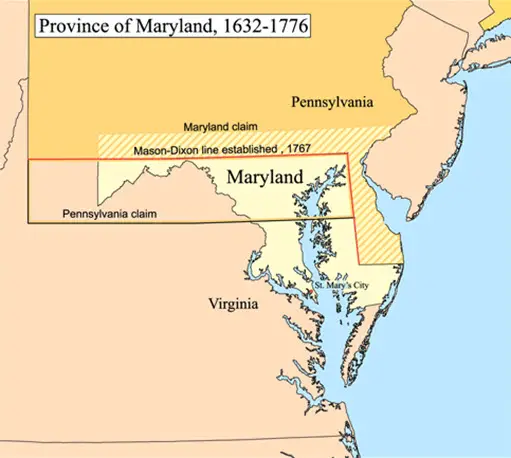
Next in the Thirteen Colonies is the Province of Maryland, which existed from 1632 until 1778. Maryland’s first settlement and capital were St. Mary’s City. It was located in the southern end of St. Mary’s County- a peninsula in the Chesapeake Bay.
This province was initially a proprietary colony of Baltimore, the English Lord. His idea for Maryland consisted of an English Catholics’ sanctuary in the modern world, fueled by the religious wars on the European side.
Likewise, among the Thirteen Colonies, Maryland was one of the earliest pioneers to tolerate religious issues. However, during the initial years, disagreement on religious matters persisted among Puritans, Quakers, Anglicans, and Catholics.
Consequently, the Puritans took specific control of the Province of Maryland.
Consequently, in 1689, John Coode steered a rebellion that removed Lord Baltimore, a Catholic, from power in Maryland.
It was only in 1715 that the power in the colony was restored to the Baltimore family when Charles Calvert, the 5th Baron of Baltimore, insisted that he was a Protestant in public.
9. Colony of Virginia (Estb. 1607)
Chartered in 1607, the Virginia Colony was North America’s 1st English colony to endure settlement.
The Virginia Company’s founder was an English trading company chartered by King James I. The object of the Virginia Company was colonizing the eastern coast of America.
In like manner, two of the early settlements in Virginia were Jamestown, located on the James River’s northern bank, and the Popham Colony, located on the banks of the Kennebec River.
However, the Popham colony failed in the first two years of settlement due to famine, disease, and conflicts with local Native American tribes.
Correspondingly, Jamestown, located on the land that belonged to the Powhatan Confederacy, was also on the verge of failing. The failure was saved by a new tribe of settlers who came along with supplies in 1610.
Virginia’s first export was tobacco in the bargain of seizing land from Native American tribes. The production and export of tobacco significantly impacted society and the colony’s settlement patterns.
8. Province of Pennsylvania (Estb. 1681)
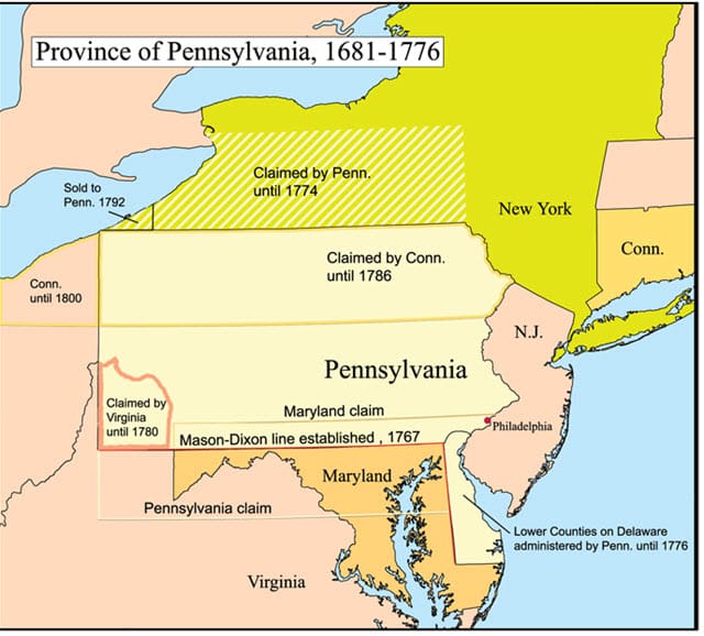
William Penn established the Province of Pennsylvania in 1681. He obtained a grant from Charles II of England to establish this province. Pennsylvania, which originates from “Penn’s Woods,” refers to William’s father, Admiral Sir William Penn.
Pennsylvania was a significant Restoration colony resulting from land grants by King Charles II to reward his supporters.
The Penn family held the proprietary colony’s charter until the American Revolution ousted them in 1765 when the Thirteen Colonies created the Commonwealth of Pennsylvania and made it one of the original thirteen states.
7. Province of New Jersey (Estb. 1674)
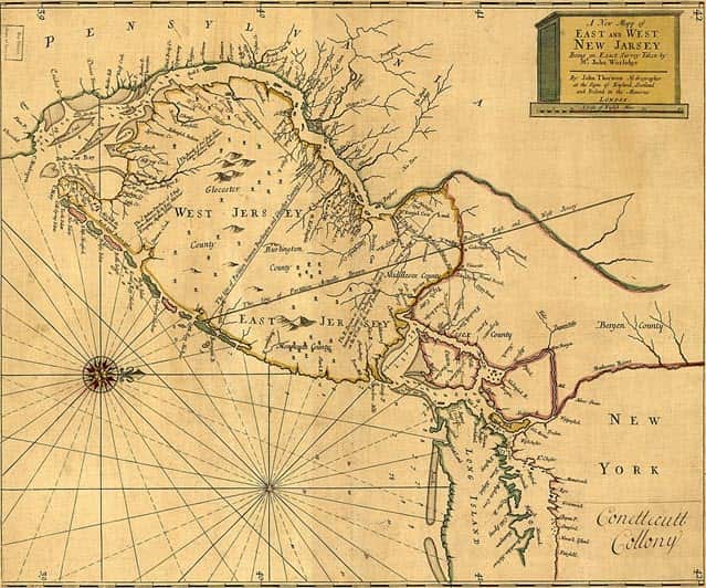
One of the Middle colonies, New Jersey, became the U.S. state of New Jersey in 1783. Europeans were the first to settle in the province as part of the New Netherlands.
However, New Jersey came under English rule after the surrender of Fort Amsterdam in 1664. The Second Anglo-Dutch War gave the English control over the entire Mid-Atlantic region.
After annexing the province, the English renamed it the Bailiwick of Jersey in the English Channel. However, the Dutch Republic did reassert control of the province for a brief period in 1673–1674.
This ushered in the political division of the province, which consisted of East Jersey and West Jersey. Nevertheless, both divided sections of the province united as a royal colony in 1702.
6. Province of New York (Estb. 1664)
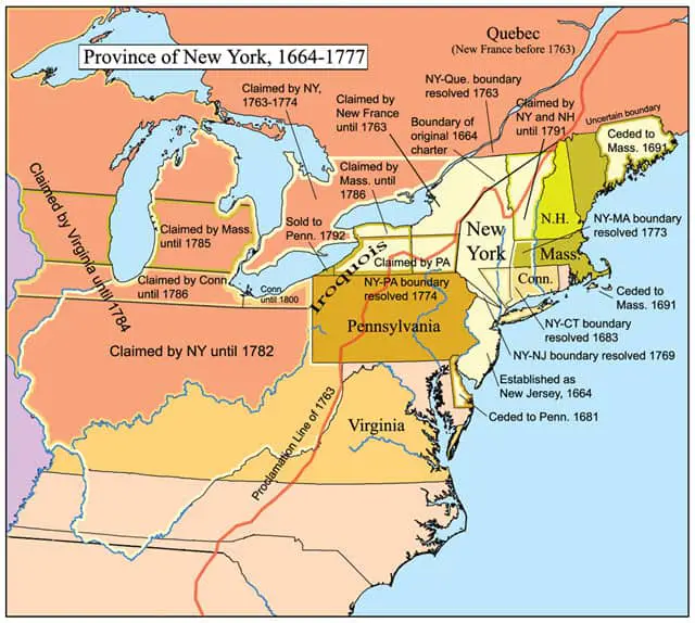
Perhaps the most famous present-day legacy of the Thirteen Colonies, the Province of New York was one of the Middle protectorates.
It was a British crown colony established by Colonel Richard Nicholls in the former Dutch colony of New Netherland. York Shire (present-day downtown New York) was the province’s capital.
By the 1690s, New York was the largest importer of enslaved people. It was also a supply port for pirates. As a result, the black population in New York was the province’s primary element, including large upstate farms.
Slave markets in New York were common during the time, with white owners conducting trade and selling black people through auctions to the highest bidder.
5. The colony of Delaware (Estb. 1776)
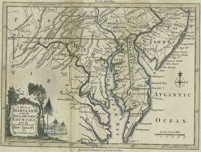
Another Middle protectorate of the Thirteen Colonies, Delaware, included the land on the western bank of Delaware’s River Bay. This land formerly belonged to the Ancient Assateague tribes and the Lenape.
The Swedes were amongst the early Europeans to settle here, and the colony of New Sweden located at Fort Christina was inaugurated in 1638.
However, Delaware was taken over by the Dutch in 1655, and the area was extended up to the New Netherland.
Subsequently, in 1644, the colony’s control was taken over by the Englishmen. Furthermore, the proprietor – William Penn, mentioned above of Pennsylvania, leased Delaware from York’s Duke – James in 1682.
The years between 1682 and 1701 marked the leasing of Delaware’s lower counties by Penn and were ruled as one of the parts of Pennsylvania. During this, Delaware’s lower counties proposed the independence petition and were approved as the independent colonies.
4. Colony of Rhode Island (Estb. 1663)
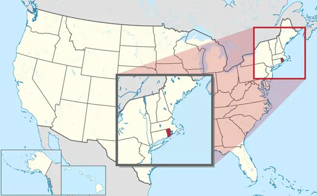
Bordering the Atlantic Ocean, the Colony of Rhode Island was one of the original Thirteen Colonies founded by Roger Williams on America’s east coast.
Much like the rest of the colonies, the land first belonged to the Narragansett Indians. Subsequent European settlement began around 1622.
Roger Williams, the founder of the Rhode Island colony, was a Puritan linguist and theologian. He also founded the Providence Plantations in 1636. Rhode Island was the only New England colony with no established church.
In addition to the 109 places of worship with regular services in the eight British American colonies by 1650, Rhode Island only had 4 (2 Baptist and 2 Congregational). There also was a small Jewish enclave in Newport by 1658.
3. Connecticut Colony (Estb. 1636)
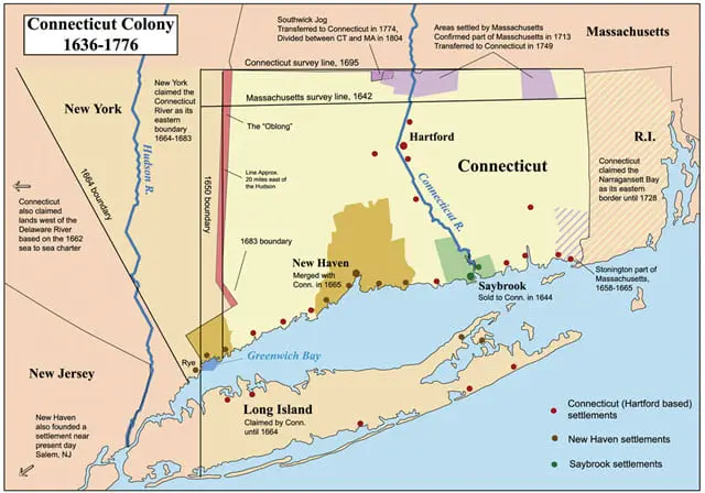
Originally known as the Connecticut River Colony, the Connecticut Colony was one of the Thirteen Colonies in New England organized on March 3, 1636, as a settlement for a Puritan congregation. In 1637, the English permanently gained control of the region after struggles with the Dutch.
Connecticut was later the site of a bloody war between the colonists and Pequot Indians. This was known as the Pequot War.
The colony’s refusal to surrender local authority to the Dominion of New England was essential in establishing self-government in the New World. This event is known as the Charter Oak incident.
2. Province of New Hampshire (Estb. 1629)
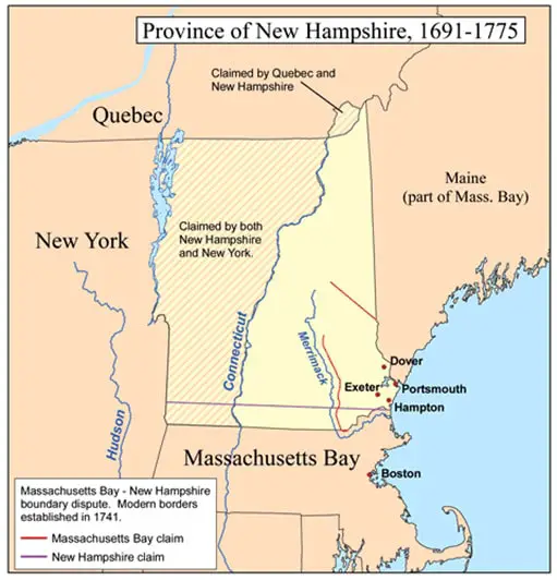
One of the Thirteen Colonies of the British Province, the Province of New Hampshire, was named by Captain John Mason after the county of Hampshire in southern England.
John Mason was its first named proprietor. In 1776, the province founded an independent state and government, joining twelve other colonies to form the United States.
Europeans were the first to settle in New Hampshire in the 1620s. For many years prior, the province consisted of a small number of communities along the seacoast, the Piscataqua River, and Great Bay.
In 1641, the proprietors organized the communities under the government of the Massachusetts Bay Colony. King Charles II later issued a colonial charter for the province, appointing John Cutt as the President of New Hampshire in 1679.
1. Province of Massachusetts Bay (Estb. 1691)
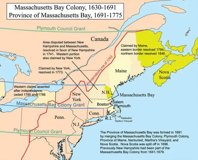
Chartered on the 7th of October, 1691, the Massachusetts Bay Province was founded under Queen Mary II and King William III, the joint monarchs of Ireland, England, and Scotland.
The charter came into operation on the 14th of May, 1692, comprising the Colony of the Massachusetts Bay, Maine Province, the Plymouth Colony, Martha’s Vineyard, Nantucket, Nova Scotia, and New Brunswick.
The name Massachusetts originates from the Massachusett Indians, an Algonquian tribe. It translates to “at the great hill,” which references the Blue Hills.
The shores of Massachusetts Bay saw colonial settlement in 1620, with the founding of the Plymouth Colony.
Conclusion
The Thirteen Colonies were the foundations of the first states that made up America. Many colonists’ institutions and towns, like churches and schools, are still around today.
Moreover, the people who settled and populated the colonies- Europeans, Africans, and Native Americans- came from many backgrounds and traditions. As such, modern America, in consequence, is a land of diversity and multiculturalism.
